A Trip Up North: the DMZ
This weekend I finally made the trek I’ve been meaning to do for awhile: a trip to the DMZ, or De-Militarized Zone, the rigidly peaceful line that crosses on the 38th parallel between North and South Korea. I will admit that after the attack by North Korea on the island of YeonPyeong in late November, a cool fall day on which I returned from a trip to the Post Office only to be greeted by a group of my students screaming, “Teacher! Fire! Death! Soldiers, die, War!” and by others, “Teacher! Go hoooommmeee nowwww, Teacher, America, Go!!!”, and to then run up to the then- deserted teacher office and subsequently eat dinner, alone, with the handful of students still in school, as we used our chopsticks and picked our way through an eerie silence– after that unforgettable experience, which had eerily similar feelings to September, 11, 2001, I thought I’d let the two Koreas simmer for awhile before making my way north.
As it was, other than the strict military procedure and knowledge that the North Korean army had their eyes trained on our every move as we stood on the border, it was an incredibly interesting experience. The highway that ran north along the river was separated from the river by thick coils of barbed wire on top of a tall chain fence, guarded by small lookout buildings with armed soldiers standing watch, due to a sneak attack by DPRK (or Democratic People’s Republic of Korea, inf. North Korea) soldiers that snuck into the ROK (Republic of Korea, inf. South Korea) via the river in the early 1960s, attempting an attack at the ROK presidential Blue House.
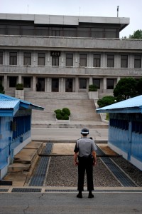
An ROK soldier stands at the ready, in a tense taekwondo pose that suggests he is ready to fight at any moment. He faces the beige DPRK building. The blue buildings to the left and right of the soldier are Conference buildings used for tightly- militarized meetings between the two countries.
We arrived at Camp Bonifas and were given a tour brief before being led to tour the Joint Security Area, including the Freedom House, a conference room built directly over the MDL, or Military Demarcation Line, the line which neither side is allowed to cross. We were driven to a lookout building that looks directly out to the North Korean propaganda city of Kijong-dong, which boasts what used to be the world’s tallest flagpole at 160m, that North Korea constructed after a bit of a ‘flagpole war’ between the north and the south.
We passed the site of the 1976 Axe Murder site, in which DPRK soldiers attacked two soldiers that were trimming a tree and murdered them with axes, which led to increased restrictions on the permissibility of soldiers in the DMZ, and then we drove to the Bridge of No Return. The Bridge of No Return was constructed for the means of prisoner exchanges at the end of the Korean War in 1953. The POWs were given a choice to remain in their country of captivity or to cross over the bridge, to the other side and, consequently, the other country, on the condition they could never return.
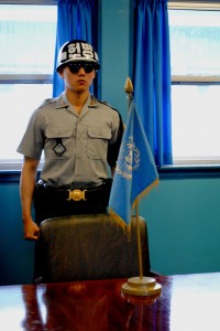
This ROK soldier stands in the main Conference Room, a blue building that is built directly on top of the Military Demarcation Line. He stands in an aggressive pose and wears sunglasses so as to prevent showing any emotion to the DPRK soldiers.
We then left Camp Bonifas and drove to the 3rd Infiltration Tunnel. As the story goes, after the Armistice Agreement was signed in 1953, North Korea has made continual breaches against the agreement in attempts to attack South Korea, though they deny them all. South Korea has discovered four tunnels that stretch from North Korea, underneath the DMZ and into South Korea, on a path to reach Seoul. One tunnel was discovered accidentally by a South Korean army patrol in 1974. Another tunnel was discovered in 1975, the third in 1978 on information provided by a North Korean defector. The fourth tunnel was discovered in 1990. There are thought to be 17 tunnels in all. The tunnels are dynamited paths through granite, anywhere from 1.2 m to 2 m high and 0.9 m to 2.0 m wide, between 50 m and 160 m below ground, paved by the DPRK with dynamite provided by the Soviet Union. Totally wild. We got to climb down into the 3rd Infiltration Tunnel via a sloped intersection access slope dug by the ROK and into the tunnel, in which it is estimated that 2,000 DPRK soldiers could pass through in the span of one hour.
We then visited the Dora Observatory, a point at which you theoretically can see the farthest into North Korea, far enough to spot a 20 m high statue of Kim Il Sung that sits in PyeongGang. Unfortunately for us, the day was hazy and grey and we could barely see out past the hill we were standing on. Apparently there exist more than 13,440 statues of Kim Il Sung in North Korea. Also totally crazy.
We then went to visit Dorasan Station, a completely finished train station that is waiting to connect the two capitol cities of North and South Korea, those being PyeongYang and Seoul, respectively. If and when the two countries are able to resolve this deeply cutting conflict that divides the country into fiercely militarized halves, Dorasan Station waits eagerly to be one of the first emblems of connection and peace, and stands ready to be the final connection in creating a Trans- Eurasian Railway Network that connects from the southernmost tip of Korea, up into Russia and across the continent all the way through Europe and into the southernmost tip of France (or Portugal?) Totally wild. Just imagine!
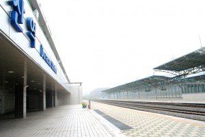
Dorasan Station facing towards Seoul. The station stands 56 km from Seoul and 205 km from Pyeongyang and, if opened, could potentially connect the Trans Eurasian Railway from the southernmost tip of Korea across Russia to the southernmost tip of France.
The school day bustles around me, phones ringing and footsteps tapping across the office floor, papers flying across the room as the breeze through the window picks up, teachers arguing over tests and students laughing and chatting in the hallway as they leave school for the day, and it seems hard to believe that the nation is so tensely on guard against their brother to the North. I sincerely wonder what will happen. It is such a fascinating relationship, a 58- year hibernation with occasional snores and burps of activity that seem increasingly close to provoking a wake up…
Alas. Here are a handful of pictures from the weekend. Enjoy.
